

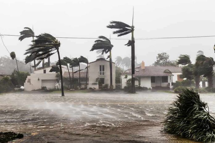
When a Category 5 hurricane runs parallel to Mexico’s Pacific coast, the most consequential risk is rarely the eyewall; it is the long fetch of water and rain it drives into steep, flood‑prone terrain and low‑lying shorelines, even if the center never crosses the beach.
At a Glance
- Hurricane Polo is a dangerous, major hurricane forecast to approach Baja California Sur on Monday; a Hurricane Watch is in effect for parts of the peninsula.
- Threat profile: destructive winds near the core, life‑threatening flooding rain and mudslides, storm surge along exposed coasts, and large, dangerous surf.
- Track guidance emphasizes an offshore or near‑shore path, but outer rainbands can still deliver damaging impacts far inland.
- Preparations become difficult once tropical-storm-force winds reach the coast; watches are issued to buy that narrow window of time.
What forecasters are saying and what the watches mean
The National Hurricane Center (NHC) has been explicit: Polo is forecast to approach the west coast of the Baja California peninsula on Monday as a hurricane, and a Hurricane Watch is in effect for that region. A Hurricane Watch signals that hurricane conditions are possible within the watch area, typically issued about 48 hours before the first arrival of tropical‑storm‑force winds — the point at which further outdoor preparations become risky or impossible. In recent advisories, forecasters also flagged that additional watches may be needed on the east side of the peninsula as the circulation expands and the wind field grows.
Intensity estimates and satellite diagnostics have reflected a high‑end major hurricane, with peak winds that, at times in the cycle, have met Category 5 thresholds. Public guidance has consistently coupled wind messaging with water hazards — heavy rain, storm surge, and large swells — because these are the mechanisms that most often cause fatalities and severe damage, particularly along Mexico’s complex Pacific slopes.
How a powerful offshore hurricane still causes onshore damage
Eastern Pacific hurricanes frequently ride the coastline rather than striking it head‑on. That geometry can be deceptive. Even if the eye remains offshore, the storm’s outer rainbands sweep ashore in waves, training over the same watersheds, and the onshore wind component piles water against concave stretches of the coast. In Guerrero, Michoacán, Colima, and Jalisco, steep mountain catchments respond quickly: saturated soils fail, producing mudslides; narrow valleys funnel runoff, producing flash floods; and surf overtops beaches, ports, and low roads. During Polo’s evolution, federal and local officials spotlighted these risks precisely because the forecast track showed a close pass rather than a bull’s‑eye, yet the rain and surf threats remained life‑threatening.
Farther north, Baja California Sur’s geography introduces a different vulnerability. Bays and inlets such as those near Santa Fe and Punta Eugenia can amplify surge and wave runup when long‑period swells arrive in phase with onshore winds. The NHC’s offshore waters guidance has highlighted extreme seas and hurricane‑force winds over the open Pacific; the coastal translation is prolonged battering surf, dangerous rip currents, and pockets of coastal flooding where topography and tides align.
Track, timing, and the narrow prep window
For emergency managers, the three clocks that matter are the track, the arrival of tropical‑storm‑force winds, and the rainfall onset. The official forecast keeps Polo offshore but close — a near‑shore pass can bring sustained tropical‑storm conditions well ahead of any core approach, closing the window to secure property, stage barriers, clear drains, or relocate to safer ground. That is why the watch product exists and why it often precedes definitive track certainty; it signals a risk significant enough to act before the details sharpen. As of the latest guidance, heavy rainfall could begin impacting Baja California Sur late Sunday into Monday, with watches extended or added as confidence in local impacts increases.
Because Polo’s forward motion has varied during its life cycle, periods of slower movement near the coast would compound hazards: more time for onshore flow to stack surge, more wave sets to erode dunes and seawalls, and more training rainbands to oversaturate slopes. Conversely, a slightly faster pass reduces duration but not necessarily peak intensity of impacts at any one point along the coast — a reminder that “missed landfall” is not synonymous with “minor effects.”
Wind versus water: communicating the real risk
The Saffir–Simpson scale classifies hurricanes by sustained wind speed, and Polo has spent time at the top of that index this season. Yet forecasters and researchers have steadily warned that wind alone miscommunicates the deadliest threats. In Mexico’s Pacific states, most catastrophic outcomes flow from water: storm surge in exposed coastal pockets and, inland, orographic rainfall that triggers flash flooding and landslides. NHC products and partner briefings during Polo’s run have emphasized this hierarchy — water first, wind next — aligning with long‑term fatality statistics and with the basin’s terrain‑driven vulnerability.
For residents and local officials, that means preparedness that prioritizes water management: clearing culverts and drainage, pre‑positioning pumps and earth‑moving equipment in slide‑prone zones, hardening back‑up power at water and wastewater facilities, and setting conservative triggers for sheltering people in flood basins. The watch‑to‑warning cadence is designed to cue these decisions in time; waiting for the exact landfall point wastes the one commodity storms always erode — time.
Hurricane Man, Josh Morgerman, chasing #Hurricane #Polo on Baja California Peninsula, Mexico
2 landfalls expected
– W coast Baja California Sur, Monday – Category 2
– NW coast of Mexico, Tuesday4-10” (~10-25cm) rain
Potential flooding, mudslides: BCS, Sinaloa, Chihuahua https://t.co/lGps9b73FT
— RBClouston (@rbclouston) September 26, 2026
What to watch through landfall approach
Three signals will determine outcome: the radius of tropical‑storm‑force winds, the storm’s angle relative to the peninsula, and the placement of persistent rainbands. A modest wobble toward the coast increases wind damage and shortens prep time; a wobble away lowers wind risk but can still deliver multiple days of swell and periodic squalls. Swell forecasts that call for life‑threatening surf and rip currents along mainland Mexico migrating north to the Baja coast are not peripheral headlines — they are the public‑facing translation of 18–27 foot seas just offshore. Mariners, port authorities, and coastal communities should align closures and beach restrictions accordingly.
Sources:
feedpress.me, nhc.noaa.gov, va.gov, reuters.com, english.elpais.com