

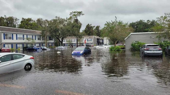
Thailand’s 2026 flood season was never one storm — it was a cascade, in which monsoon rainfall, a subsiding capital, aging drainage, and a river basin pushed past capacity all failed in sequence rather than in isolation, turning a routine rainy-season event into the country’s worst flood disaster in more than a decade.
Key Points
- Flooding that began in mid-September 2026 eventually touched 50 provinces, affected more than four million people, and damaged roughly 270,000 hectares of farmland, according to NASA Earth Observatory’s synthesis of the event.
- Thai government disaster updates trace a fast-moving footprint: 27 provinces plus Bangkok on September 28, expanding to 29 provinces and 2.6 million affected people by September 29.
- The trigger was meteorological, not mysterious: a strengthening low-pressure system combined with the southwest monsoon drove sustained heavy rainfall, as confirmed by Thailand’s Meteorological Department and the U.S. Embassy’s weather alert.
- Death tolls and affected-population figures climbed steadily through early October — from 23 deaths and 2.6 million affected on October 3, to 31 deaths and 3.5 million affected by October 5, to 44 deaths and more than 3.1 million affected by October 8.
- Bangkok’s exposure is structural as much as meteorological: land subsidence from decades of groundwater extraction has left large parts of the capital barely above sea level, a vulnerability experts had flagged years before this flood season arrived.
What Actually Happened, and When
The flooding began in mid-September 2026 and intensified through the final week of the month, when a strengthening low-pressure system merged with the southwest monsoon to produce sustained, heavy-to-very-heavy rainfall across the country. By September 28, Thailand’s Department of Disaster Prevention and Mitigation was reporting impacts across Bangkok and 27 provinces, touching 151 districts, 792 subdistricts, and more than 576,000 households. The footprint widened almost daily: one day later, the official count stood at 29 provinces plus Bangkok, 940,300 affected households, and 2,602,309 people. By the time NASA’s Earth Observatory published its summary of the event in October, the cumulative national tally had grown to 50 provinces, more than four million people, and roughly 270,000 hectares of damaged farmland — a scale that places 2026 among Thailand’s most severe flood years since the catastrophic 2011 disaster, which killed more than 800 people and affected some 13 million.
Bangkok’s own crisis unfolded inside this larger national story. The capital’s flood barriers, built around the Chao Phraya River’s historical flow capacity, held through the initial surge, but a combination of upstream dam releases, saturated ground, and high tides repeatedly narrowed the city’s margin for error. Suvarnabhumi Airport’s baggage and staffing failures — which led to the dismissal of Thai Airways’ chief executive — became the visible, viral face of a crisis whose deeper damage was accumulating in rice paddies, shrimp farms, and poultry operations far from the capital’s cameras.
The Human and Agricultural Toll
Casualty and damage figures moved steadily upward as the event stretched across weeks rather than days. The Interior Ministry’s count stood at 23 deaths and roughly 2.6 million affected people across 42 provinces by October 3; by October 5, ABC News reported 31 deaths across eight provinces, including four in Bangkok, with more than 3.5 million people still affected nationwide. By October 8, that toll had climbed to 44 deaths with over 3.1 million people affected. None of these figures contradict one another — each was accurate for its reporting date — but together they illustrate how a slow-moving, multi-week disaster resists the kind of single, fixed headline number that a faster-moving event would produce.
Agricultural losses compounded the human toll. Thailand’s Ministry of Agriculture and Cooperatives reported 1,644,172 rai of cropland affected — equivalent to roughly 263,000 hectares — across 42 provinces, a figure closely matching NASA’s independent estimate of about 270,000 hectares. Rice fields bore the brunt, alongside orchards just weeks from durian and mango harvest, and poultry and shrimp operations where losses were sudden and total rather than gradual. Economic analysts at the University of the Thai Chamber of Commerce and at Krungsri Research placed total damage in the tens of billions of baht, with estimates running as high as 0.19 percent of GDP — modest in macroeconomic terms, but concentrated devastatingly among farming households with little capacity to absorb a lost season.
Why the Capital Floods Even When the Rain Stops
Bangkok’s vulnerability is not purely a function of rainfall; it is a function of geography altered by decades of human activity. The city sits on a low-lying delta, and groundwater extraction over the twentieth century caused measurable land subsidence, eroding the natural elevation that once helped the Chao Phraya River basin shed floodwater on its own. Climate researchers have described what was once a roughly thirty-year flood cycle for the basin becoming an almost annual concern, a shift attributed to both intensifying rainfall patterns and the city’s shrinking natural defenses. Independent event-attribution analysis has similarly pointed to a persistent monsoon low-pressure system, rather than a single discrete storm, as the rainfall driver behind the late-September surge — a mechanism consistent with, though more specific than, the general monsoon-and-low-pressure description in official Thai and U.S. advisories.
Reading the Numbers Honestly
Readers tracking this disaster across multiple weeks will notice province counts, household totals, and death tolls that shift from one government bulletin to the next — 27 provinces, then 29, then 42, then a cumulative 50 in later summaries. This is not inconsistency in the pejorative sense; it reflects a hazard that genuinely expanded and contracted as rain bands moved, rivers crested on different schedules in different basins, and tidal cycles periodically blocked drainage in the capital even as upstream flooding eased. The honest way to read Thailand’s 2026 flood season is as a rolling event with a growing cumulative footprint, not a single snapshot disaster — and by any reasonable reading of the official record, it ranks among the country’s most consequential weather disasters in more than a decade.
GISTDA Records 4.21 Million Rai Flooded During October 3–9, 2026
GISTDA’s flood-monitoring dashboard recorded 4.2 million rai of flooded land during October 3–9, 2026. Nakhon Sawan had the largest flooded area among the provinces displayed, at 642,236 rai.
Ayutthaya followed… pic.twitter.com/bVuBlMM00W
— Thai Enquirer (@ThaiEnquirer) October 9, 2026
Sources:
science.nasa.gov, thailand.prd.go.th, thailand.go.th, reuters.com, abcnews.com, en.thairath.co.th, nationthailand.com